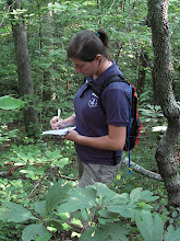
 The first challenge was to mark the property boundary of Williams Woods. A professional/official survey would cost over $6,000 and involve technology way out of my league. Bob Cross, President of the Ozark Society, volunteered for the job with his personal GPS unit. Although his markers are not perfectly accurate, nor are they accepted by the county as official survey, his work was a big help in my study. In later months, we will mark the property boundary with higher accuracy GPS units for GIS mapping and it was good to find out what kind of terrain and other potential obstacles might exist.
To determine property boundary lines, Bob looked at the deed description, which says things like "
 the Northwest Quarter of the Northwest Quarter (NW 1/4), containing 40 acres, more or less, being in Section 33, Township 14 North, Range 26 West." The Public Land Survey System, set up after the Northwest Ordinance of 1787 through the vision of Thomas Jefferson, carved the United States up into rectangular "townships," each 6 miles square. Each township was divided into 36 "sections," which were further subdivided into corners to ease surveying. The Arkansas territory was surveyed beginning in the early 1800s... this was no easy feat. Teams of men slogged through Delta swampland and steep, forested Ozark hills with primitive survey equipment of the day-- long chains, compasses, and log books.
 As you can imagine, error was inevitable. When GPS became accessible to the public in the 1990s, property boundary surveys became much more accurate. A landowner might find that his property lines were "off" by sometimes 60 feet or more when corrected using GPS. At Williams Woods, several fence lines were 20 to 30 feet over from the line given by our GPS unit. This inconsistency might be explained by decreased accuracy of the GPS unit because of tree cover, or perhaps the barbed wire fence was erected using an older, less accurate survey technique. I guess we'll find out when we return with high-accuracy GPS units.
 Currently, each corner of the property is marked with a wooden stake, and flagging tape marks our path about every 10 feet. The total distance around the property was over 5 miles. We came to cliff faces and streams and downed trees... but it was important to continue in a straight line so we did our best! The journey made it easier to imagine what it must have been like for the original surveyors in the 1800s. Hard. Very.
No comments:
Post a Comment